Tropical Storm Erin Poised to Become First Hurricane of 2025 Atlantic Season
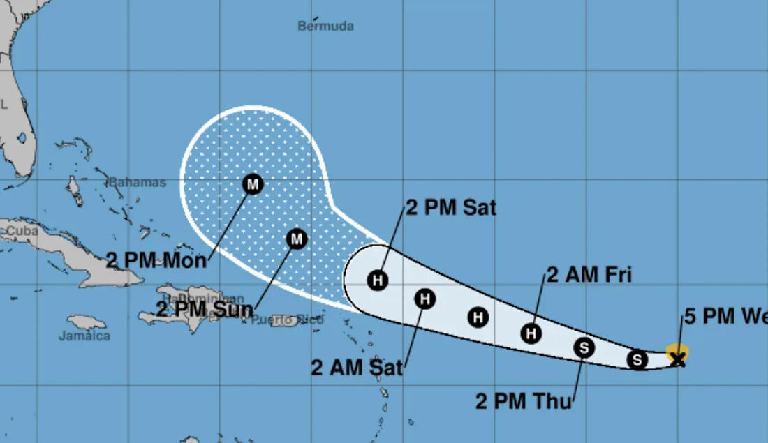
Tropical Storm Erin, which formed in the eastern Atlantic Ocean earlier this week, is on track to become the first hurricane of the 2025 Atlantic hurricane season by the end of this week, according to the National Hurricane Center (NHC). As the storm strengthens and moves westward, forecasters are monitoring its potential impact on the U.S. East Coast, the Greater Antilles, and the Bahamas.
Current Status and Path of Tropical Storm Erin
As of 5 p.m. ET on Wednesday, Erin is situated approximately 1,200 miles east of the northern Leeward Islands. The storm boasts maximum sustained winds of 50 mph and is currently moving west at a speed of 17 mph. The NHC has indicated that this general motion is expected to persist into Thursday, with a shift to a west-northwestward trajectory beginning Thursday night and continuing into the weekend. On its projected path, Erin is likely to approach or pass just north of the northern Leeward Islands over the weekend.
Potential for Intensification
The NHC’s intensity forecast suggests that Tropical Storm Erin could escalate to hurricane status "in a day or two." Gradual strengthening is anticipated over the next couple of days, with forecasters predicting that Erin will reach hurricane status by Friday. A tropical storm is classified as a hurricane when its maximum sustained winds reach at least 74 mph. Hurricanes are categorized on a scale from Category 1 to Category 5, with Category 3 and above considered major hurricanes.
Watches and Warnings
As of Wednesday evening, there are no coastal watches or warnings in effect. However, the NHC has cautioned that swells generated by Erin will begin affecting parts of the northern Leeward Islands, the Virgin Islands, and Puerto Rico by the weekend. These swells pose a risk of life-threatening surf and rip current conditions, prompting residents to consult local weather forecasts for updates.
Overview of the 2025 Hurricane Season
The 2025 Atlantic hurricane season, which commenced on June 1 and will continue through the end of November, has a 50% chance of being above normal in terms of storm activity. Last week, the National Oceanic and Atmospheric Administration (NOAA) revised its forecast, now predicting 13 to 18 named storms, with five of those potentially becoming major hurricanes. Historically, a typical hurricane season averages around 14 named storms, and so far this season has seen five named storms: Andrea, Barry, Chantal, Dexter, and Erin.
In summary, as Tropical Storm Erin continues to develop, it serves as a reminder of the unpredictable nature of hurricane season. Residents in affected areas should remain vigilant and stay informed through reliable weather sources.
This article encapsulates the current situation regarding Tropical Storm Erin while providing essential information about its potential impact and the broader context of the 2025 hurricane season. The structured format and clear headings enhance readability, making it suitable for both casual readers and those seeking detailed information.


